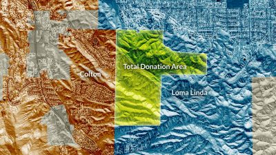
Understanding the terrain
In its entirety, the donated site is 430 acres of privately-owned, undeveloped land on the east side of Reche Canyon. The land is defined by a central valley corridor surrounded by ridgelines and has varied terrain, including flat, rolling, and steep topography.
Reche Canyon’s natural beauty is one of the main features of Rancho del Prado and conserving it is one of the priorities of the plan. Dictated by the terrain (which defined placement of housing, roads, parks, and open space), the plan limits the amount of earth-moving required.
Public services
The land is accessed by Prado Lane on the north and Crystal Ridge Lane on the south. It is currently within the City of Loma Linda’s physical boundary, but it is not serviceable by the city.
University Realty is therefore working with the City of Colton to bring this land into Colton’s purview and exploring how best to bring future public services— including fire protection, water, and wastewater infrastructure—to the land and the surrounding community.
Conserving open space
The 203-acre Rancho del Prado project area will include more than three miles of recreational trails, 8.3 acres of open space parks, and 87 acres of conserved open space.
Beyond the 95+ acres of parks and open space within the project area, the plan would set aside an additional 227 acres of open space conserved in perpetuity with public trail access, protecting the ridgelines to the northeast. Taken together, the project and additional conservation area comprise 322 acres of parks, trails, and open space—representing approximately 75% of the overall 430 acre land area.
Frequently asked questions
Rancho del Prado will embrace and honor this natural setting, protect ridgelines, and minimize visual impacts of any development. The project will also emphasize the natural elements and site features through thoughtful design. Specific environmental impacts must be studied as required by the state’s California Environmental Quality Act (CEQA). The CEQA process is described in detail here.
No. Loma Linda’s Measure V is concerned about the visual impacts and infrastructure development of the treasured hills in the southern part of the city. However, Rancho del Prado will have no visual impacts on Loma Linda. Intervening hills block the view of Rancho del Prado from greater Loma Linda, and streets and other infrastructure will not connect to the City. Because of this, the architects of Measure V have given their assurance that the development of this project in Colton does not violate the letter nor the spirit of Measure V.
Yes. The grading plans are not finalized, but the Rancho del Prado Specific Plan conceptual site plan is consistent with the City of Colton grading guidelines. The grading design prioritizes contoured natural features, ridgelines, and conserved open space. In addition, the grading design will incorporate hillside development best practices and standards while minimizing onsite earth movement. The clustered grading concept builds on the design characteristics of the adjacent developments and retains connections to existing recreational trails and access roads.
We are aware of and have studied the San Jacinto fault zone which runs adjacent to the northern property line. As required in this location along the fault zone, several technical studies have been prepared to verify the location of any known active faults. The geotechnical engineer preparing the evaluation has provided site plan feedback throughout the design of the site plan. Secondary effects of seismic activity are considered unlikely. Development within Rancho del Prado will be required to adhere to industry accepted setbacks from the San Jacinto fault, and all homes would be built in accordance with 2019 California Building Code seismic safety requirements.
